16KM Strong Signal Livestock Monitoring Drone Level 5 Wind Resistance and GPS
Product Overview: Unrivaled Aerial Surveillance for Modern Agriculture
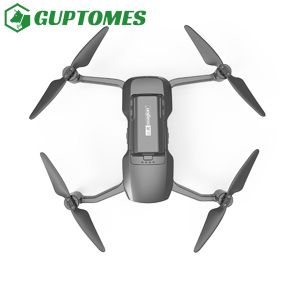
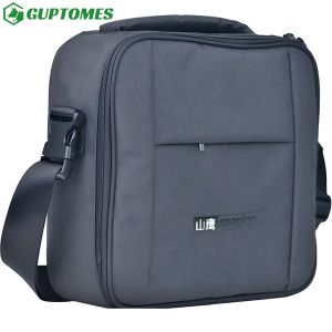
The Sealion 007 is a powerful, long-endurance professional Unmanned Aerial System (UAS) engineered specifically to meet the rigorous demands of modern large-scale farming and livestock management. Combining a robust flight system with advanced imaging technology, the Sealion 007 provides actionable, real-time data to optimize operations, enhance animal welfare, and secure your valuable assets across vast and remote territories. Take control of your acreage with the ultimate precision aerial tool.
Core Features & Technical Specifications
1. High-Definition Imaging & Data Capture
- 4K UHD Camera System: Equipped with a 4K resolution camera mounted on a stable 3-axis anti-shake mechanical gimbal, ensuring crystal-clear, steady video and photographic evidence for detailed inspection.
- HDR (High Dynamic Range) Color Reproduction: Captures exceptional image quality with vivid color, essential for accurate visual assessment of pasture health, water sources, and animal condition, even in challenging lighting.
- Video & Data Recording: Supports simultaneous 4K Video and 20MP photo capture, with all data swiftly exportable to your devices via Wi-Fi or directly via an SD card slot.
2. Extended Endurance & Performance
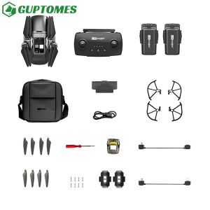
- Intelligent Power Management: Powered by two 5000 mAh Intelligent Lithium batteries, providing an extended flight time of up to 40 minutes on a single charge. The intelligent battery system regulates voltage to maximize power consumption efficiency.
- Robust Wind Resistance: Maintains stable flight and imaging quality in high wind speeds up to 10m/s (Level 5 Wind), ensuring consistent performance in diverse outdoor conditions.
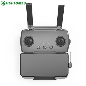
- Extended Range Control: Features a strong signal and reliable 4G communication module, extending the effective transmission distance for control and video up to 10km (FCC) / 6km (CE).
3. Smart Navigation & Safety
- Precision GPS Positioning: Utilizes dual GPS positioning for highly accurate location tracking, automatic return-to-home functionality, and precise, repeatable flight paths.
- Automated Failsafe Return: The drone is programmed for automatic return-to-home (RTH) initiation when the battery level is critically low or the control signal is lost, prioritizing the safety of the aircraft and data.
- Enhanced Visibility for Night Operations: Integrated with specialized flight navigation lights and a scientific lighting design, facilitating safe and effective operation in low-light and nighttime conditions.
Product Applications: Optimize Your Operations
| Application Area |
Key Functionality |
User Benefit |
| Livestock Management |
Herd and Flock Monitoring: Rapidly locate and count animals across large paddocks. Health Check: Utilize high-res zoom and HDR to visually inspect animals for distress, injury, or signs of illness without disturbance. |
Reduced labor time, proactive animal welfare, and accurate headcounts. |
| Pasture & Land Surveying |
Real-Time Aerial Surveillance: Conduct live video streaming (1080P/30fps) for immediate visual assessment of land, fences, and infrastructure. Water Source Inspection: Quickly check remote troughs and dams. |
Immediate situational awareness, early detection of infrastructure failure, and improved grazing management. |
| Asset Security & Patrol |
Automated Patrol Routes: Program fixed flight paths to routinely monitor perimeter fences, gates, and valuable equipment. |
Deterrence of trespassers, quick identification of security breaches, and increased peace of mind. |
| Mapping & Reporting |
Data Export & Analysis: Easily extract geo-tagged photos and video for integration into mapping software and historical record-keeping. |
Informed decision-making, trend analysis, and simplified compliance documentation. |
Frequently Asked Questions (FAQ)
Q1: What is the maximum flight range and communication distance for the Sealion 007?
A1: The drone supports an effective transmission distance for control and video of up to 10km (FCC) and 6km (CE). This is supported by its strong signal transmission system and advanced 4G communication module, providing reliable control even at long distances, surpassing traditional Wi-Fi only systems.
Q2: How does the drone perform in strong winds?
A2: The Sentinel Scout 007 is rated for excellent wind resistance, maintaining stable flight control and imaging quality in winds up to Level 5, or approximately 10m/s.
Q3: Can I view the video in real-time?
A3: Yes, the drone provides a real-time live video transmission feed at 1080P/30fps, which can be viewed and recorded via the dedicated remote control and the associated app.
Q4: Is the drone capable of night operations?
A4: Yes. The drone is designed with built-in, scientific navigation lights, which ensure safe flight and good visibility in low-light environments, making it suitable for night-time surveying and security patrols.
Q5: What happens if the battery runs low or I lose the signal?
A5: The drone features an intelligent safety system that initiates an Automatic Return-to-Home (RTH) function. If the battery falls below a critical threshold or the control signal is lost, the aircraft will automatically navigate back to its take-off point.
provides actionable, real-time data to optimize operations, enhance animal welfare, and secure your valuable assets across vast and remote territories. Take control of your acreage with the ultimate precision aerial tool.